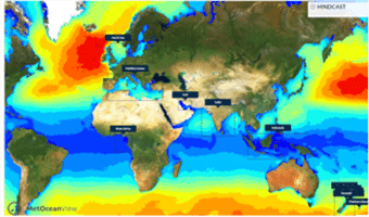
Numerical modelling and hindcast data
Coastal and offshore studies rely on quality atmospheric and oceanographic data to ensure that the ambient and extremes of the climate are appropriately taken into account. Numerical hindcasting techniques provide an efficient and cost effective method to generate these data. It is a rapidly deployable, powerful tool for providing information on metocean parameters, going back to 1979, providing key inputs to optimize the safety, efficiency and durability of commercial marine operations and structures.
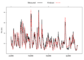
We run the latest models and use the most advanced techniques. With local measurements for calibration and validation, the atmospheric and oceanic (including coastal) processes and extreme historical events are replicated with high accuracy.
Metocean hindcast data
You receive accurate, localised long term record of marine conditions at any open ocean or coastal location around the world. Metocean data is made available as gridded data (for spatial analysis), statistics or time-series. Our hindcast archives include the following metocean parameters:
- Wind data – wind speed and direction
- Wave data – wave height, period and direction for total, swell and wind sea
- Currents – tidal, residual and combined
- Water level – tidal height/elevation, surge
- 2D wave spectra
Hindcast data is available from different global models as well as from high resolution regional models. Regional model data is available for the North Sea, Irish Sea, Mediterranean, Persian Gulf, Bay of Bengal and South East Asia.
The following metocean statistics are available through our web interface
- Monthly Statistics => Wave height, Wind speed
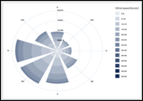
- Wind roses & wave roses
- Scatter Table 2D => Wave height vs. direction, wave height vs. peak wave period, Wind speed vs. direction
When required we can carry out additional detailed modelling for critical operations and/or complex environments. We can also run detailed models for landfall locations, estuarine and ports.
Modelling capabilities include:
- Atmospheric modelling using WRF
- Wave generation, propagation, and transformation – from the open-ocean to within ports and harbours, using SWAN, WW3, CGWAVE and FUNWAVE.
- 2D and 3D hydrodynamic solutions for tidal, wave-driven, wind-driven or regional low-frequency flows can be applied to regional or local scale geographies. Operational forecasting and hindcasting of tidal, wind and pressure driven flows is carried out using POM. Fully three dimensional baroclinic models can also be implemented, with ROMS for coastal oceans or the finite element SELFE for estuarine and complex coastal environments.
- Dispersion and transport of sediments, pollutants and objects are studied using lagrangian particle solutions.
- Oil spill modelling using the GNOME oil spill model integrated with our current models.